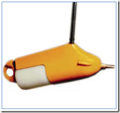
Equipment used in the measurement of sediment transport (sediment transport) is based on the standard United States. Geological Survey (USGS), the equipment has been developed by the Federal Inter-Agency Project sedimentation (FIASP). Gauge / sampling sediments that have been standardized by FIASP, has a specific code that can be interpreted as follows:
US: gauge / sediment sampling with standard United States.
D: Integration into the depths (depth integrating).
Q: Integration Point (point integrating).
H: Hanged / held with a stick / stick / handlebar or rope, while suspended by cables / sounding, reel, without code / letter H.
BM: Material basis (Bed Material)
U: Standard Single (Single stage).
YEAR: Year of manufacture / developed (written, the last two digits).
Here is described one piece of equipment to take samples of sediment discharge float, ie the depth integrating sampler. This tool is designed in such a way in order to capture the flow of water mixed with sediments in the upright position and speed of the flow of the incoming flow to the nozzle will have a value anywhere near the speed of flow around it. This tool is used in a way down to the bottom of the river and picked up close to the surface with the velocity of the same. One type of this measure is commonly used, namely the US D-48.

Figure 5. Depth 48 integrating sampler
USLE Integration with Geographical Information Systems (GIS)
USLE was developed to estimate the lost ground on the land with a small size, so that in its application for estimating sediment Yil (not losing ground) basin, all factors (except R) should be calculated by weighting. Furthermore, if the land use or practical conservation in the watershed varies over space, erosion must be calculated individually for each area, and also required modification factors USLE price.
The most appropriate way to accommodate the characteristics of each spatial extent is the application of Geographical Information Systems (GIS). The use of Geographic Information Systems as a system of data collection organized today began to grow rapidly. And this has been proven in several agencies both public and private that uses Geographic Information Systems as a collection system and a unified data integration.
There are some interesting things why the concept of GIS is used, even in a variety of disciplines. Among them;
1) Almost all operations (including analysis) owned by interactive GIS devices are supported with easy to access menus (user friendly).
2) ability to decipher the entity that is in the earth’s surface on a spatial data layer format. Thus the surface can be reconstructed or modeled in the form of a real using elevation data and thematic layers required.
3) Applications – GIS application provides the facility to be customized with the help of scripts language program owned software SIG or even able to integrate with the other applications that are compiled with the programming language that is more sophisticated (Visual Basic, Delphi, C ++).
4) Software GIS provides the facility to communicate with applications – other applications to be dynamically exchange data either through the facilities of OLE (Object Linking and Embedding) ma upun ODBC (Open Database Connectivity) to access remote data. Additionally SIG has been widely implemented in the form of software components that can be reused by the user who wants a digital map display (especially vector format) on the application with the ability and quality standards.
5) At this time the user is at a remote location from the data source to access GIS data by implementing GIS map-server or server-ready to serve requests (queries) the client via the intranet or the Internet (web-based).
So that the workload can be separated between the client and the server. In addition, the application of GIS-application can be made on the server or on the client. Server will organize and provide services to all incoming queries from users (clients).
Thus the product of GIS application can also be freely published on the Internet to be accessed using an Internet browser application. Thus for managing these complex data, required an integrated information system that is capable of processing both spatial data and attribute data to further be able to answer the question of spatial and attribute simultaneously. It is expected that the existence of an information system that is efficient and capable of managing data with complex structure and a large amount of these can help in the decision making process.