The process of transporting sediment (sediment transport) can be described includes three processes as follows: Blow rain (rainfall detachment), the material sediments that are above the ground as a result of spark erosion (splash erosion) can move the particles of the soil will be transported together -Same surface runoff (overland flow). Furthermore washed away into the grooves (rills), and so on into the sewers and eventually into the river.
Sediment deposition process occurs, occurs when the flow rate can be raised (pick up velocity) and transport materials deposition of sediments reaching speeds (settling velocity) which is influenced by the size of the particles of sediment and flow rate. Sediment Discharge Ratio Calculation (Sediment Delivery Ratio) or simply known as the SDR is a calculation to estimate the amount of sediment result of a water catchment area.
Calculation of the SDR is important in determining the magnitude realistic forecasts based on the calculation results of the total sediment total erosion that took place in the catchment area. This calculation depends on the factors influencing the relationship between the magnitude of the results of the sediment and the amount of total erosion that took place in the catchment area generally varies. Variability SDR figure of a watershed will be determined: Sources of sediment, the amount of sediment, transport systems, Texture particles eroded soil, sediment deposition location and characteristics of the watershed (Asdak C., 2007).
At a media, the Head of the Central River Region Pompengan Jeneberang Adang Saff Ahmad had expressed, due to the occurrence of landslides Mount Bawakaraeng that occurred in the year 2004, has produced material sediment (mud) in the Watershed (DAS) Jeneberang 230 million / m3 , Various efforts to control the flow of this material continues to be done, including building sand bag dots (sand pocket) to resist the flow of sediment.
The state of sedimentation in the watershed Jeneberang, obtained data showing subzone Jeneberang downstream (which is traversed by the river Jeneberang) got heavy mud / water amounting to 41,200 mg / liter (in research 20 November 1996). Then subzone Jenelata (which is traversed by the river Jenelata) has a heavy sedimentation with sludge / water amounted to 132,800 mg / liter. While in Phase II (28 July 2004) the state of sedimentation highest in sub watersheds Jeneberang Downstream of 4.75 million mg / liter, subzone Jenelata amounted to 13 467 mg / liter.
This indicates severe sedimentation has occurred within a period of 11 years in Sub-watershed Jeneberang Hilir. The level of erosion hazard is classified in the category of weight is to subzone Jenelata area of 9535.56 ha. While in the subzone territory Lengkese and Malino, Gowa generally fall into the category of being with each spacious 8231.4 and 8016.04 Ha Ha. In subzone Jeneberang Hilir and subzone Tallo, the rate of erosion is generally classified as a category is very light with each area 22370.98 hectares and 18 525, 27 Ha.
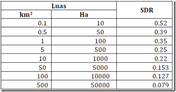
The amount of SDR in the calculations of erosion or sediment results for a river basin is generally determined using a graph watershed area and the amount of SDR as stated by Roehl (1962) in Asdak C. (2007). Relations watershed area and the amount of SDR can be seen in Table 1.
Table 1. Relations watershed area and Sediment Delivery Ratio (SDR)

Being another way to determine the amount of SDR is to use the equation:
![]()
Average total sediment is allowed within a watershed is the product of the SDR with tolerance to soil erosion, the amount of tolerance to soil erosion, according to Thompson (1957) depending on the nature of the soil and its location.