A map projection is a system which gives the relationship between the position of points on the earth and on the map. Because the physical earth’s surface is irregular, then it is hard to perform calculations on the results of size (measurement). Was selected for a field that is regularly approaching physical field is the field of the earth ellipsoid ...
Read More »Home > Author Archives: Taufiqullah (page 10)
Author Archives: Taufiqullah
Persiapan Lokasi Pengeboran
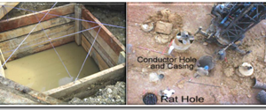
Kebutuhan pertama membuat jalan tembusan menuju lokasi yang telah ditentukan tentu akan memerlukan peralatan, lahan dan personal. Jalan ke lokasi harus disurvei, untuk melihat jarak yang terpendek, keramaian jalan, kekerasan dan lebar jalan, kekuatan dan lebar jembatan. Persiapan jalan ke lokasi ini harus memperhatikan keselamatan kerja, baik terhadap pekerja, peralatan, maupun lingkungan, mengingatperalatan-peralatan pengeboran yang melintasi besar dan berat. Persiapan ...
Read More »Developments Drilling Method
Increasing number of problems in the drilling operation requires the development of more advanced technology. In the development of several drilling methods have been used, some methods of drilling has been performed, among others: 1. Drill mashed How to make a drill hole is made by mashing numbukkan drill the soil layers to be penetrated. The drill bits are constructed ...
Read More »Spatial Data Source
One type of data in GIS are spatial data, which can be obtained from several sources, among others: 1) Data Map Analog Data Map analog (among others topographic maps, soil maps, etc.) that maps in printed form along with the results scannya. Analog map created by cartographic techniques, are likely to have such a spatial reference coordinates, scale, direction of ...
Read More »Comparison Vector and Raster Model
Both raster and vector data models each have characteristics or tendencies, its own advantages and disadvantages. Nevertheless, bearing in mind that the objective nature and human needs can be different from each other and even changed from time to time, then none of the data model that really can meet all the needs of the representation and analysis of spatial ...
Read More »Creating Map
The last process of mapping is to create a map, either in print or digital form. To create a layout map go through the process after going through the process of setting symbology and label. 1) The first step in doing layout is enabled toolbar layout. 2) Add the data to be used in map 3) Set the layer composition, ...
Read More »