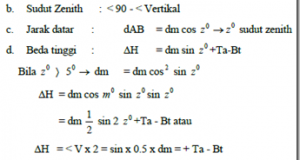
Jenis tugas : Pengukuran Situasi Cara Polar Koordinat Metode Tacheometry Tanpa Magnit. Alat pengukuran : Pesawat Theodolit TL 6 DE Statif Rol meter Palu Rambu ukur Daftar pengukuran Data board Patok/paku Keselamatan kerja : 1. Periksa alat-alat pengukuran sebelum dibawa ketempat pengukuran. 2. Periksa lokasi pengukuran dari keadaan/lalu lintas kendaraan agar tidak mengganggu pengukuran. 3. Melakukan kerja sama yang baik ...
Read More »Garis Lurus Antara Dua Titik Melalui Rintangan
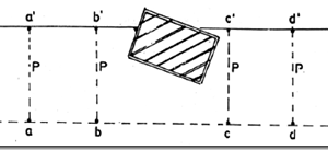
1. Petunjuk a. Perhatikan dengan baik lokasi di mana kita akan melakukan praktek. b. Perhatikan dengan saksama lembaran pekerjaan dan langkah-langkah kerjanya. c. Mengincar yalon harus pada dua posisi/sisi (kanan dan kin). d. Menancapkan yalon harus tegak (bukan selalu tegak lurus permukaan tanah). e. Pemasangan yalon-yalon harus tepat sesuai titik-titik yang telah ditentukan. f. Membuat laporan kerja 2. Peralatan dan ...
Read More »Bangunan Utama Irigasi Air
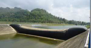
Bangunan utama sistem irigasi dapat didefinisikan sebagai kompleks bangunan yang direncanakan di sepanjang sungai atau aliran air untuk membelokkan air ke dalam jaringan saluran agar dapat dipakai untuk keperluan irigasi. Bangunan utama bisa mengurangi kandungan sedimen yang berlebihan, serta mengukur banyaknya air yang masuk. Bangunan utama terdiri dari bendung dengan peredam energi, satu atau dua pengambilan utama, pintu bilas, kolam ...
Read More »Reading Signs Measure
As described earlier, measuring buoy serves as a tool in determining the height difference by plane carpenter’s level, measuring signs usually consist of some kind, such as Figure 24 below. Beacon beacon Interval Interval 5 mm 10 mm Figure 24 To get the height of a point, the necessary data from the measuring buoy readings, see sample results ukurr signs ...
Read More »Peta Pengukuran Tanah
Salah satu kegunaan pengukuran tanah adalah untuk membuat peta. Peta adalah gambar dari permukaan bumi, yang dilihat secara vertikal dari atas pada suatu bidang datar. Gambar dalam peta mencakup atau memuat segala sesuatu yang terlihat pada permukaan bumi dan memuat segala sesuatu yang diperlukan untuk pembuatan peta. Dalam menggambar permukaan bumi yang disebut peta, harus digunakan skala proyeksi tertentu. Dengan ...
Read More »Membaca Rambu Ukur
Seperti dijelaskan sebelumnya, rambu ukur berfungsi sebagai alat bantu dalam menentukan beda tinggi dengan menggunakan pesawat sipat datar , rambu ukur biasanya terdiri dari beberapa jenis, antara lain seperti gambar 24 di bawah ini. Rambu Interval 5 mm Rambu Interval 10 mm Gambar 24 Untuk mendapatkan ketinggian suatu titik, diperlukan data dari suatu rambu bacaan ukur tersebut, lihat contoh hasil ...
Read More »


