The way the provision of irrigation water are included in the administration of water through the surface, can be distinguished as follows: 1. Irrigation System wild flooding (wild flooding) is a surface irrigation system where water digenangkan on a large area, so that the surface soil becomes waterlogged high enough, so the cropping area will be quite perfect in pembasahannya. ...
Read More »Home > Author Archives: Taufiqullah (page 24)
Author Archives: Taufiqullah
Measure Map Situation With Compass
1. Instructions a. Carry out work in accordance with the work step. b. Rotate compass | clockwise. c. Make reports the measurement results. 2. Equipment and Supplies a. Compass. b. Statief (tripod). c. Measuring tape. d. Yalon-and stakes. e. Notebook. 3. Safety a. At the time of measurement, minimize / avoid metal objects around the compass. b. Wear work clothes, ...
Read More »Perancangan Saluran Irigasi Permukaan
Sebelum membuat suatu sistem irigasi permukaan, maka dalam tahap perancangan harus dibuatkan terlebih dahulu lay out atau tata letak sistem irigasi permukaan. Lay out atau tata letak sistem irigasi harus menunjukkan hal-hal berikut, (1) Lokasi bangunan utama, (2) Trase jaringan irigasi dan pembuang, (3) Batas-batas dan perkiraan luas (dalam ha) jaringan irigasi dengan petak-petak primer, sekunder dan tersier serta daerah-daerah ...
Read More »The Process of Surface Irrigation Systems
By using surface irrigation systems, the water flowed from the river, stored and released from the pitcher (reservoir) or pumped from the ground and then given to the land. Excess irrigation water must be removed from the land. Each component requires the design, operation, and maintenance of regulatory and control structures. In order for the system to be efficient and ...
Read More »Analisa Data Topografi Sistem Irigasi
Data topografi lahan merupakan data penting yang sangat menentukan keber-fungsian jaringan irigasi permukaan. Pengukuran dan pemetaan topografi merupakan kegiatan awal yang harus dilakukan dalam perencanaan sistem irigasi permukaan. Pemetaan bisa didasarkan pada pengukuran di lapangan secara penuh, sehingga dihasilkan peta topografi yang dilengkapi dengan garis konturnya. Untuk sistem irigasi dengan luas lahan sekitar 10.000 ha atau lebih biasanya didasarkan pada ...
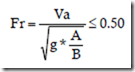
Read More »Perancangan Saluran dan Jaringan Irigasi
a. Menentukan ketinggian muka air di bangunan sadap Tinggi muka air di bangunan sadap tersier pada saluran primer atau sekunder dapat dihitung dengan persamaan berikut : P = A + a + b + c + d + e + f + g + h + z Dimana: P = ketinggian muka air di saluran primer atau sekunder A = ...
Read More »