When tillage combined with the soil conservation biopori hole will go well, because the water that originally infiltrated difficult it will be easier to seep down. Biopori a hole made with a diameter of 10 cm and depth of 100 cm covered / filled organic waste which serves to trap / catch / hold water flowing around it so it ...
Read More »Tanaman Mucuna (Leguminosa pansan)
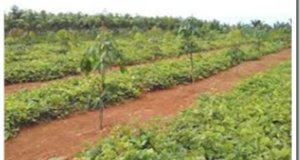
Mucuna sp atau tanaman Koro benguk (Jawa) dapat digunakan sebagai tanaman yang dapat menghasilkan biji berprotein tinggi dan dapat memainkan fungsi rehabilitasi lahan secara khusus. Biji Mucuna dapat dibuat tempe atau setelah direbus selama 24 jam akan dapat pula dicampur dengan ubi kayu untuk meningkatkan gizi ubi kayu. Beberapa keuntungan rehabilitasi Iahan tidur dengan tanaman penutup tanah seperti Centrocema dan ...
Read More »Land Rehabilitation Sleep
Damage to land or lots of land degradation in dry land, especially in parts of the planted crops and smallholder agriculture. Degradation of land because land is often open by the work of tilling and weeding clean so easily eroded soil. The utilization of barren land into agriculture is not economical because productivity is so low. Until now, efforts to ...
Read More »Tipe Bendungan Berdasarkan Fungsinya
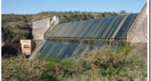
Ada 8 tipe yaitu : 1) Bendungan pengelak pendahuluan (Primary coffer dam) adalah bendungn yang pertama-tama dibangun di sungai pada debit air rendah agar lokasi rencana bendungan pengelak menjadi kering yang memungkinkan pembangunan secara teknis. 2) Bendungan pengelak (coffer dam) adalah bendungan yang dibangun sesudah selesainya bendungan pengelak pendahuluan sehingga lokasi rencana bendungan utama menjadi kering, yang memungkinkan pembanguna secara ...
Read More »Pengolahan Tanah Dengan Pembuatan Biophory
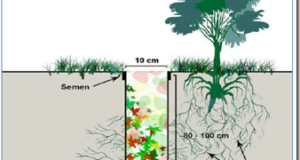
Bila pengolahan tanah dikombinasikan dengan lubang biopori maka konservasi tanah akan berjalan dengan baik, Karena air yang semula sulit terinfiltrasi akan lebih mudah meresap kebawah. Biopori merupakan lubang yang dibuat dengan diameter 10 cm dan dalamnya 100 cm yang ditutupi/diisi sampah organik yang berfungsi untuk menjebak/menangkap/menampung air yang mengalir di sekitarnya sehingga dapat menjadi sumber cadangan air bagi air bawah ...
Read More »Destination Region
According to Mathieson and Wall (in Gunn, 1994), tourism is the temporary movement of people to destinations outside the normal workplace and residence, the activities carried out during their stay at the destination, and the facility was created to meet their needs. While the World Tourism Organization (2011), defines travel as a social phenomenon, cultural and economic mobility requirements of ...
Read More »